Dublin’s City-Scale AI Enabling Data‑Driven Active Travel & Road Safety Decisions in the Region

Dublin has teamed up with VivaCity and Bentley Systems to create a real‑time digital twin that fuses sensor, traffic and environmental data, enabling data‑driven decisions for safer, greener travel across the city and its boroughs.
Smart Dublin, an initiative of the four local authorities in the Dublin region to support innovation, has been trialing new technology to measure and monitor active travel and support Dublin City Council’s ambitious goal: to ensure that everyone in the city is within five minutes or 500 metres of an active‑travel route. Achieving this means upgrading streets, junctions and public space to support walking, cycling and other modes, and using data to make the right decisions and evaluate the impact of schemes. As part of this vision, Dublin is trialing a new digital twin which brings together multiple data feeds in real time.
Working together to create an end-to-end solution for Dublin, Bentley Systems and VivaCity follows the NVIDIA Blueprint for smart city AI, a workflow that enables city-scale AI from simulation to training to deploying with video analytics AI agents.
The proof-of-concept platform combines Bentley Systems’ 3D geospatial platform Cesium and NVIDIA Omniverse to enable real-time visualization and analysis of active travel sensor data. Dublin currently uses Vivacity’s AI traffic sensors, powered by NVIDIA Jetson and NVIDIA Metropolis platforms, to collect multimodal traffic data and behaviour insights on various types of road users, achieving very high levels of accuracy in identifying close passes for cyclists, drivers and pedestrians across Dublin’s roadways. All these streams are fused into a 3D model of Dublin that updates in real time, enabling transport planners to see what’s happening on the ground and to simulate future changes.
The platform also ingests additional data types from Dublinked, Dublin’s open‑data portal, and presents them in a unified 3D environment. Integrating data into Cesium/Omniverse allows users to connect to datasets such as geospatial mapping, traffic reports, weather and water levels through a unified portal. The platform overlays these counts on the 3D map, colour‑coding locations by volume or safety metrics. Weather information can be layered to explore correlations between rainfall and cycling, while historical data supports time‑series analysis.
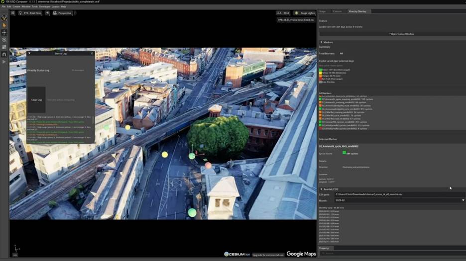
Overview of the Dublin region data visualisation platform developed in partnership with Bentley Systems, using VivaCity transport data, powered by NVIDIA
Early Insights and Lessons Learned
Although the project is still a proof of concept, the partnership has already generated useful insights:
- Cycling resilience to weather: By combining VivaCity’s cycling counts with rainfall data, the platform showed that rainfall had a negligible impact on the number of cyclists on Dublin’s roads (insight from project synopsis). This challenges assumptions that bad weather deters active travel and strengthens the case for investing in cycling infrastructure.

Traffic insights aggregated on the Dublin platform uncovered that rainfall has minimal impact on cycling in the city
- The Dublin team noted that they observed 800 – 1,000 cyclists during daily peak hours on the Clontarf‑to‑city‑centre, a notable increase on the pre-infrastructure investment estimates.
- Demand exceeds expectations: The data have been “really good,” and committees within Dublin City Council are using them to justify investment in active travel. The new infrastructure is seeing higher usage than originally forecast, demonstrating latent demand for safe cycling routes. Smart Dublin has also integrated the data into their Active Travel Dashboard – which brings together data from VivaCity, the Irish census Google EIE, Strava Metro and EcoCounter.
As Jack Kavanagh, Dublin City Council’s Open Data Lead, explains: “Our aim is that every resident is within five minutes or 500 metres of a walking or cycling route. This digital twin is for data insights so that we can measure and monitor and make better data‑driven decisions. It’s the first time we’ve been able to get these insights so quickly and all in one place. This pilot project is really exciting and best positions the Dublin region to address the future urban challenges that arise in keeping active travel safe and accessible for all.”
Mark Nicholson, VivaCity’s CEO, commented “Collaborating with Dublin, Bentley, and NVIDIA on this digital‑twin and AI agent initiative is incredibly exciting for us. We believe our highly accurate sensor data is the perfect match for the city’s integrated platform, and it’s already delivering insights that can help understand and impact how Dublin moves. We’re looking forward to continuing supporting the Smart Dublin team to unlock more insights from the data and enable safer and more sustainable journeys for everyone.”
Dublin’s digital twin initiative exemplifies how city leadership, industry partners and open data can come together to tackle real-life urban challenges, as the mobility demands of the Irish capital region grows. The combination of accurate edge‑AI sensing, real‑time 3D visualisation and open data integration provides a robust foundation for evidence‑based policy.
The proof of concept will be showcased at the Smart City Expo World Congress 2025 in Barcelona in the City of Dublin booth. If it proves successful, Dublin’s experiment could become a reference for other cities, showing how open data, AI‑enabled sensors and a shared platform can enable data‑driven decision‑making and support healthier, more active travel.
To find out more about VivaCity, visit their website here.
The ITS UK Member News Service shares announcements and press releases from member organisations. The content is solely the responsibility of the issuing organisation and does not imply endorsement by ITS UK.